Tracking Telematics & Beacon Technology
Device Location Tracking and Reporting
- supports a wide range of protocols and device models. You can select GPS trackers from a variety of vendors
- includes a modern fully-featured web interface with both desktop and mobile-friendly layout
- native mobile apps for Android and iOS platforms
- view your GPS devices in real-time. Various mapping options, including Google road maps and Google satellite imagery
- provides notifications for email, SMS, Whataspp, Telegram. Allows for external alerting due to driver behavior – speeding, fuel management, maintenance events, Geo-fencing and other alerts relating to your vehicle CAN
- event reporting provides location, trip, chart and summary information. View the data on any device.
- reporting device location history – mapped at 1 second intervals, providing visual representation
Beacon Technology – How it Works
THE BASICS OF BEACON TECHNOLOGY
Understanding the technology is crucial to making well-informed decisions. Therefore, before we cover all differentiators of today’s Bluetooth LE (Bluetooth Low Energy) hardware, we must set the groundwork and clear out some common misconceptions about beacon technology.
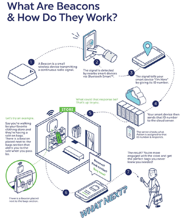
What is a beacon and how does it work?
- A beacon (or a tag, as we’ll discuss later in this chapter) is a small wireless device that
- works based on Bluetooth Low Energy.
- It’s kind of like a lighthouse: it repeatedly transmits a constant signal that other devices can see. Instead of emitting visible light, though, it broadcasts a radio signal that is made up of a combination of letters and numbers transmitted on short, regular intervals. A Bluetooth-equipped device like a smartphone, gateway, or access point can “see” a beacon once its in range, much like sailors looking for a lighthouse to know where they are.
- The information that beacons broadcast is called an advertising packet. The advertising packet contains basic information about the device (its ID, the firmware it runs on, and the battery level), as well as its transmission power, calibrated RSSI (Received Signal Strength Indicator) at 1 meter, and, depending on the vendor and the device, other bits of data, like sensor readings.
In some cases, such as path finding, beacons can transmit the location data but this is not used frequently. The location data of the beacon is calculated based on three combined factors:
- its transmission power (the power at which it broadcasts the signal)
- its reference RSSI (the strength that the signal achieves at this set transmission power
- at the range of one meter from the beacon)
- the actual RSSI (the signal strength at the location where the signal was picked up by a receiver)
As you can see, the beacon data is pretty useless if there’s no device that can capture it and no piece of software that can interpret it. This is why any beacon-based project requires at least two more components: a receiver and an application.
A receiver is a Bluetooth-enabled device that “listens” to beacon signals in its range and passes all the information it grabs to the application. The application computes the data and translates it into whatever it was programmed to show.
This is hopefully an easy-to-understand but generic setup. To show you how this usually works in the real world, we need to draw an important distinction between a beacon and a tag.